 Photo: Ontario Parks
 Algonquin - Hwy 60 Corridor
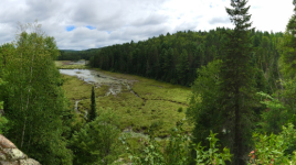
on parkswhat to expect
Along the 56-kilometre stretch of Highway 60 through Algonquin Provincial Park there are numerous day use opportunities. Be sure to pick up a copy of our Information Guide when you arrive for more details. Amenities: Algonquin Visitor Centre, Logging Museum and Art Centre Educational Discovery Programs during the summer months 14 interpretive hiking trails ranging from 1 km to 10.8 km 2 bike trails 6 day use picnic areas with washroom facilities 9 boat launches (check maximum horsepower restrictions) 3 lodges Several restaurants, rental facilities and gift shops Accessible walking trails and facilities Limited cell phone service Hwy 60 is a paved highway, but many of the secondary roads are gravel.
Description: Ontario Parks
the basics
The campsites
Things to do nearby
Within 5 km — trails, viewpoints, beaches, boat launches you can reach without packing up camp.
- Oxtongue Lake
Plus 1 user-tagged viewpoint on OpenStreetMap — visible as pins on the map below.
What's around
Algonquin - Hwy 60 Corridor plus 1 named place to see and do nearby — trails, beaches, viewpoints, water, and services.
Water + services
- Nearest dump station
- Nearest potable water
what to bring
This list adapts to Algonquin - Hwy 60 Corridor. no showers means a travel towel;
If Algonquin - Hwy 60 Corridor is full
Other places to stay within 25 km — ones with openings in the next 14 days listed first.
- Oxtongue River - Ragged Falls Provincial Park openings
- High Lake Campsite, Limberlost Forest
- Buck North 5, Limberlost Forest
- Buck North 1, Limberlost Forest
- Algonquin Pines Campground
- Maple Leaf 9
- Maple Leaf 10
- Maggie 9
Plus 126 user-tagged dispersed sites on OpenStreetMap — often genuine wild-pitches; check access rights before relying on one.