 Photo: Ontario Parks
 Sandbar Lake Provincial Park
on parks inside Sandbar Lake Provincial Parkwhat to expect
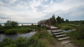
Sandbar Lake Provincial Park is located approximately 12 km north of the Trans-Canada Highway 17 from Ignace on Highway 599. This park offers car camping, seasonal campsites, two group campsites, and day use opportunities. A beautiful well-treed, small campground, this park's name exemplifies its character, through a range of natural sand bar formations which highlight numerous beaches around the lake including the park beach. The park offers less than 80 campsites, about half of which have electricity. Campsites can accommodate equipment ranging from tents to large trailers. The two group campsites are more privately located in the northern section of the park. Campsites at Sandbar are partially shaded with some offering a tantalizing glimpse of the lake. Park amenities include water …
Description: Ontario Parks
the basics
The campsites
Things to do nearby
Within 5 km — trails, viewpoints, beaches, boat launches you can reach without packing up camp.
Plus 2 user-tagged boat launches, 1 user-tagged beach on OpenStreetMap — visible as pins on the map below.
What's around
Sandbar Lake Provincial Park plus 2 named places to see and do nearby — trails, beaches, viewpoints, water, and services.
Water + services
- dump station node/8996917649
- dump station node/8044395655
14 user-tagged water sources, 4 user-tagged dump stations on OpenStreetMap.
what to bring
This list adapts to Sandbar Lake Provincial Park. no showers means a travel towel;
If Sandbar Lake Provincial Park is full
Other places to stay within 25 km.
Plus 2 user-tagged dispersed sites on OpenStreetMap — often genuine wild-pitches; check access rights before relying on one.